Deliver to USA
IFor best experience Get the App
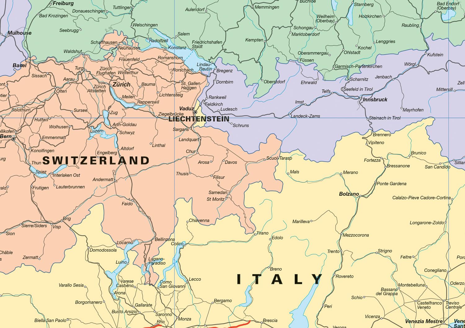
Collins Rail Map of Europe: Plan your flight-free European adventure
S**I
Useful little map
Great product, really made planning travel easier.
G**H
The next stop is
All good thanks
L**A
Large fold-out paper map.
I have to be honest, this wasn't what I was expecting, that's totally down to me, but for some reason I thought this was going to be a guide book, not a fold out paper map.What you do get is a full map of Europe on one side and a slightly more detailed area of Eastern and Western Europe on the other side along with useful travel fact, including the names of main stations in cites, when certain events are on throughout the year and travel tips.The maps show 4 different types of railway from High Speed to minor tracks and also ferry routes. Various stations are shown along the railways but obviously not all of them due to the scale of the maps.You also get 6 example routes with one or two places to visit in each city. I thought there would be more suggested routes but you only get these 6.As you would expect from a Collins product the quality is great with the print being colourful and clear and the text is all very legible, if quite small in places, get your reading glasses at the ready.Overall, A useful starting place for European rail travel but you will need further resources in order to fully plan a detailed train journey.
A**
Very helpful map
Map very informative and easy to read
A**N
Analogue Planning tool
We are planning a summer rail trip across Europe and this map was a great way to get my kids involved in the process, far better than just using apps and online, this physical map allowed them to understand the connectivity of countries and they really enjoyed that.The map itself is quite detailed and whilst it won't be completely realtime the majority of services we checked online were printed on the physical map.
P**Y
Useful for planning an Interrail adventure
This map offers an astronaut’s perspective of travel around the continent of Europe by train. The main map is 86 x 86 cm and at a scale of more than 1 in 4 million, allows every country in Western and Eastern Europe to be seen at a glance. This does work well if planning trans-continental rail journeys such as London to Napoli, as you can see where the high speed and main railway lines run. By eliminating roads, the map is far clearer to read than a conventional Atlas.The map offers some ideas for long-distance rail routes such as DIY Orient Express, travelling from London to Istanbul. These are accompanied by colour photographs of some of the destinations but do not give any details about how you might actually make such journeys such as how long they might take or cost.The reverse side of the map has a smaller but larger scale map that just focuses on Central Europe. From a British perspective, it would have been really useful to highlight Eurostar routes that are available from St Pancras to differentiate them from routes such as the TGV routes which require an interchange in Paris.The map has the most abbreviated country guide I have seen, compressing the whole of the UK into 6 short sentences. I am not quite sure why you would want to travel from Liverpool to Manchester just so you could “go shopping…in the same day” as there are plenty of shops in Liverpool that are equally keen for your custom.This illustrates the shortcomings of this map. It promises to provide essential information about each country with country profiles, safety and sustainability tips and suggested itineraries but in reality these are condensed to just a few words. The map works well as a colourful overview of European Railway lines and would be ideal on a bedroom wall for those planning their Interrail adventures over a summer holiday. However, it really needs a companion guide or perhaps smartphone app to fill in the blanks and explain exactly why one should cross the Pennines to see what Manchester’s Northern Quarter has to offer compared with Liverpool One.
S**C
Decent map
Well laid out useful map, Informative for travelling around Europe. Protected by the thick card exterior. Will come in handy for my upcoming travels.
M**C
Practical and interesting with a lot of helpful info
I would expect a Collins Map to be excellent and this one is no exception! If you love to travel without the hassle of flying, you can get all over the place in short time and make the actual journey part of the holiday if you go by Train instead. This double sided fold out map covers Europe and Scandinavia, shows you where there are main railways, secondary railways, minor railways and High speed railways, as well as stations, Ferry routes and capital cities all clearly marked. Plus it has a ton of fascinating and helpful info to make your travels easier and more fun, for example there are some suggested routes to take covering various countries, it shows you some highlights of each different country with pictures, there is a section where it covers each month of the year and shows what interesting things to go see and where in that month such as festivals and special events. There's a helpful section called "top tips for train travel in Europe" which gives info on safety, currency, etc , a station finder, a list of tourism websites for each country and more. I find it enjoyable just looking at it, but of course it's practical too for planning your actual travels. Travelling by train is a good way to really soak up the scenery and to meet the locals as well, and this map is a brilliant up to date tool to help you on your adventures. Worth every penny!
Trustpilot
3 days ago
1 week ago