National Geographic World Map (folded with flags and facts) (National Geographic Reference Map)
Product ID: 198011484
Buy anything from 5,000+ international stores. One checkout price. No surprise fees. Join 2M+ shoppers on Desertcart.
Desertcart purchases this item on your behalf and handles shipping, customs, and support to USA.
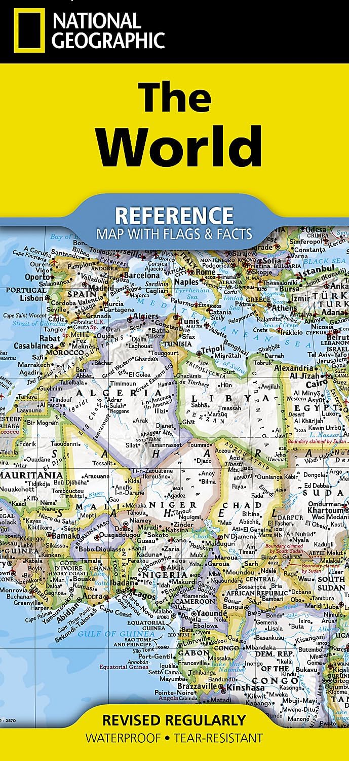
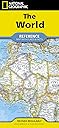
Expertly researched and designed, National Geographic's World with Flags & Facts Map is the authoritative map of the world by which other reference maps are measured. The folded world map is designed for travel and durability. Product Features: Signature Classic style map with bright, easy to read color palette with blue oceans and colorful borders Background shows mountain ranges and valleys in subtle shaded relief with mountain ranges labeled Major water bodies including rivers, lakes, glaciers, oceans, seas, gulfs, bays, straits, and bathymetry Clearly defined international boundaries , cities, islands, airports, and physical features Thousands of place names carefully and artfully placed to maintain legibility in heavily populated areas Up-to-date international boundaries and territorial control reflect de facto status on the ground Meticulously researched using multiple authoritative sources including the U.N., U.S. Board on Geographic Names, and policies of individual governments. Accurate place names use a combination of conventional English names, official national names, and standard transliterations for non-Latin alphabets. Drawn in Winkel Tripel projection with distortions minimized unlike other World maps (e.g. Greenland is shown the same size as Argentina, not South America) Corner inset maps feature vegetation, land use, population density, and north and south polar regions National facts and flags with each country's area, population, capital city, GDP per capita, and flag The map is printed in the USA on durable waterproof, tear-resistant synthetic paper to withstand repeated folding. Map Scale = 1:37,213,000 Sheet Size = 37.75" x 25.5" Folded Size = 4.25" x 9.25" Review: National Geographic is always the best! - Always order National Geographic maps only. They are by far more accurate and offer a great selection of styles! Review: Great Price & Easy to Use - Great price. Folds easily & laminating will keep it from ripping & fading.


| Best Sellers Rank | #6,627 in Books ( See Top 100 in Books ) #5 in World Atlases & Maps (Books) #9 in Geography (Books) |
| Customer Reviews | 4.7 out of 5 stars 940 Reviews |
F**6
National Geographic is always the best!
Always order National Geographic maps only. They are by far more accurate and offer a great selection of styles!
J**N
Great Price & Easy to Use
Great price. Folds easily & laminating will keep it from ripping & fading.
E**S
Fun to look at all areas of the world
Nice map made well water proof
D**D
National Geographic world map
Very informative
B**I
map is nicely detailed.
I have TRAVELED A LOT AND NICE TO SEE WHERE I HAVE BEEN...
L**Y
Great little map!
I bought this for an elderly friend in a nursing home. He traveled the world during g his career as a geologist and has so many interesting stories. He can share those stories with other friends & visitors and loves showing them on the map. It is lightly laminated, folds easily and doesn't tear. He often takes it to the dining room after lunch is cleared. It's been a great conversation starter and he just lights up when he's sharing about his adventures. It's a great little map!
T**N
What Countries Affected By Current War
Nice map. I bought some I could get a visual of all the countries that are affected by the current war in the middle east.
A**E
Huge map and no seams like an atlas
Huge map with good detail - get a magnifying glass. Folds up like a normal road map. Good bang for my buck! I recommend.
S**N
Buen mapa
Mapa de buen tamaño
B**E
Highly recommend
An awesome map. I bought it for my classroom and it is durable, waterproof and does not crease. Highly recommended.
R**O
Muito bonito
Enquandrei o mapa. Ótima qualidade de impressão e visual.
B**S
Love my map!!
Love it!
K**R
Received in good order
Good quality item
Trustpilot
2 months ago
1 month ago