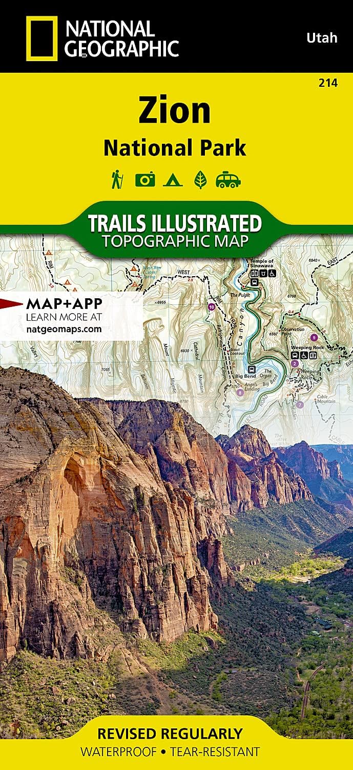

Buy anything from 5,000+ international stores. One checkout price. No surprise fees. Join 2M+ shoppers on Desertcart.
Desertcart purchases this item on your behalf and handles shipping, customs, and support to USA.
• Waterproof • Tear-Resistant • Topographic Map Explore the beauty and geological wonder of Utah's first national park with National Geographic's Trails Illustrated map of Zion National Park. Created in partnership with local land management agencies, this expertly researched map combines unmatched detail with useful information to help you get the most from your visit, including a chart detailing the extraordinary geology of Zion and a companion hiking timetable for the popular Zion Narrows. Key areas of interest featured on this map include: Zion Narrows, Kolob Canyons, La Verkin Creek Trail, Hop Valley Trail, Wildcat Canyon, West Rim Trail, Floor of the Valley Road, East Rim Trail, Telephone Canyon, and the Virgin River. With nearly ninety miles of mapped trails, trail summaries, and information about camping, lodging, and shuttles, the Zion National Park map will prove an invaluable tool on your journey. Trails are clearly marked and include mileages between intersections. The map base includes contour lines and elevations for summits, passes and major lakes. Some of the many recreation features include: campgrounds, trailheads, parking lots, designated campsites, and interpretive trails. Every Trails Illustrated map is printed on "Backcountry Tough" waterproof, tear-resistant paper. A full UTM grid is printed on the map to aid with GPS navigation. Other features found on this map include: Zion National Park. Map Scale = 1:37,700 Sheet Size = 37.75" x 25.5" Folded Size = 4.25" x 9.25" Review: Helpful, detailed map, but Zion trails are already very well marked and maintained. - I like it, but I honestly didn’t have to really use it once I was at Zion. All the trails are well marked and it’s almost impossible to get lost. The most helpful map is always the tram maps so you know what stop to take for each trail you want to do. The National park website has all the information you need, but I still like having such a nice detailed map at my finger tips! It could be a good plan B thing to have for any of the serious multi day/week/month adventure hikers out there. There are plenty of places in Zion with no signal, though GPS will work perfectly fine almost everywhere, except for the narrows. I didn’t test the water proof capability, even though I did have it in the water proof bag out on the narrows, that’s really just abmain in/out trail that follows the water, so unless you try to take a split trail in some places, you probably would just use the map to help you gauge where you are and how far you have to go. Can’t get lost on a day hike in the narrows unless your inept, but then you wouldn’t be hiking on the narrows that far if you were! Be careful though, it’s very easy to run out of water, even for the short hikes, because you shouldn’t drink the narrows water with all the algae blooms and waste in it and you’re going against the current in the beginning of most day hikes. Check the weather, the map can’t save your life if you get caught in a flood. Review: Useful in the no service park - I bought this before my trip to Zion. It was helpful in understanding the overall park. I planned out what to hike each day by using this map. One thing to understand about Zion is that there is barely any cell service. Once I started hiking past the narrows, the path is somewhat there but there is no service beyond the paved portion. This map helps orient yourself. This map is also more expensive in and near the park. I suggest getting it here before going.


| Best Sellers Rank | #34,142 in Books ( See Top 100 in Books ) #2 in Bryce Canyon & Zion National Parks Utah Travel Books #33 in West Mountain United States Travel Books #49 in Hiking & Camping Excursion Guides (Books) |
| Customer Reviews | 4.8 out of 5 stars 577 Reviews |
F**R
Helpful, detailed map, but Zion trails are already very well marked and maintained.
I like it, but I honestly didn’t have to really use it once I was at Zion. All the trails are well marked and it’s almost impossible to get lost. The most helpful map is always the tram maps so you know what stop to take for each trail you want to do. The National park website has all the information you need, but I still like having such a nice detailed map at my finger tips! It could be a good plan B thing to have for any of the serious multi day/week/month adventure hikers out there. There are plenty of places in Zion with no signal, though GPS will work perfectly fine almost everywhere, except for the narrows. I didn’t test the water proof capability, even though I did have it in the water proof bag out on the narrows, that’s really just abmain in/out trail that follows the water, so unless you try to take a split trail in some places, you probably would just use the map to help you gauge where you are and how far you have to go. Can’t get lost on a day hike in the narrows unless your inept, but then you wouldn’t be hiking on the narrows that far if you were! Be careful though, it’s very easy to run out of water, even for the short hikes, because you shouldn’t drink the narrows water with all the algae blooms and waste in it and you’re going against the current in the beginning of most day hikes. Check the weather, the map can’t save your life if you get caught in a flood.
R**I
Useful in the no service park
I bought this before my trip to Zion. It was helpful in understanding the overall park. I planned out what to hike each day by using this map. One thing to understand about Zion is that there is barely any cell service. Once I started hiking past the narrows, the path is somewhat there but there is no service beyond the paved portion. This map helps orient yourself. This map is also more expensive in and near the park. I suggest getting it here before going.
E**A
Very helpful resource
Excellent map resource, especially as a newbie to the region.
S**R
Convenient for trip planning
Saves me a trip to REI
K**Y
Not needed for a day tripper
I bought this map while researching a trip to Zion national park. We were only there two days and were in the main portion of the park. This map is a great map for people who want to get out of the main portion of the park.
B**S
Very durable
Very detailed and durable does not tear was able to put it in my bag without her getting ruined and it’s waterproof love it. Will be buying more for new hikes
C**Y
Used for my trans Zion trek
Used this for my West-to-East hike across Zion. ZNP is not a complicated trail system, but none of the trails have mileage markers. Furthermore the basic maps in the park don’t label many of the bluffs and canyons in the park; this map tells you the names of these features.
C**K
I really love nat geo's trail maps
I really love nat geo's trail maps, this things can hold up really well. I had a stack of them out on this last trip through the southwest. Its not mine if I haven't spilled coffee on it yet apparently well knocked a cup over right on the maps at first I freaked out but after a quick trying and leaving in the sun the maps weren't even phased. As for the map itself, I carry them on all my hikes and haven't been disappointed when i have to use them on the trails. Another thing I use them for is planning my photography shots, it gives me a bigger picture of everything so I know what the terrain looks like, what direction each "viewpoint" is before I ever get to the parks
J**Y
The best maps!
The coating on them makes them super strong no matter how many times you fold them.
T**E
Good guide
Very useful for off the beaten track in this wonderful nNational Park.
N**N
carte
même commentaire que pour la carte précédente itinéraire et découvertes préparés en amont que du bonheur sur place !en route
T**C
Very hepful
Really helpful for our great adventure to all the parks in that area. Didn't even have to bother with a sat nav.
B**2
Excellent pictures
I did not see this map as is gift to my daughter who lives ln the other side of Canada.. She says pictures in it are wonderful, but not able to comment on bow accurate the trail mapping is as she ended up going to a different destination.
Trustpilot
1 day ago
1 month ago