





Streetwise Tokyo Map - Laminated City Center Street Map of Tokyo, Japan
Product ID: 1562806
Desertcart purchases this item on your behalf and handles shipping, customs, and support to USA.
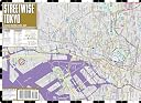
Streetwise Tokyo Map - Laminated City Center Street Map of Tokyo, Japan [Streetwise Maps] on desertcart.com. *FREE* shipping on qualifying offers. Streetwise Tokyo Map - Laminated City Center Street Map of Tokyo, Japan Review: Excellent *Map* With Subway Station Numbers! - The STREETWISE TOKYO MAP was really helpful for my first trip to Tokyo this month. Not only does it break Tokyo down into the separate districts like Shibuya, Shinjuku, Asakusa, etc., it provides icons for big hotels and landmarks, so that you can figure out where you are, and there's also a Tokyo area map showing all of the districts within Tokyo. Another really good thing about the map is the listing of subway/train station numbers and lines. This was really helpful in figuring out the route from point A to point B. We learned the hard way that Tokyo isn't an area that you can walk from one place to another, unless you're really familiar with the streets, because they aren't logically set up like here in the states. The streets of Tokyo branch out and twist and turn and you can get lost very easily! We got lost about 3 or 4 times, even when we were walking in what seemed like a straight line. Luckily, the STREEWISE TOKYO MAP shows the subway and train lines so you can just follow along the appropriate line to get from where you are to where you want to go and then head down to the station. Because the subway lines have a combination of letters and numbers, i.e. the Marunouchi line is listed on the map and in real life as "M" plus a number denoting the station stops, it's really easy to figure out which line you need to be taking and at what number stop you need to get off at. Trust the map and the numbers because there was one anomaly that appears in the Shibuya area of the map and Shinjuku. Actually it isn't an anomaly but if you walked the area, we walked from the Tokyo Gymnasium back into Shinjuku where we were staying, it would seem that Shibuya is actually above Shinjuku, but it's not. So when we decided to ride the Fukutoshin Line to get to Harujuku, after getting hopelessly lost on foot, we noticed that the station stop numbers were getting higher, instead of lower, but it was right on. The above probably makes no sense, but if you've ever walked the streets of Shinjuku and Shibuya you'll know exactly what I'm talking about. Anyway, the map is great for finding your way when you become lost, or may actually prevent it, and it'll help you figure out the subway and train lines so you can get to where you need to go. Review: A great tool for touring Tokyo - I carried this highly useful map all over Tokyo in my back pocket during a recent visit and was able to travel easily throughout the city. It's much more useful than the maps included in the guide books I have read. The combination of color, letter, and number that codes each subway station makes it very easy to know where to go and when to get off. On the larger maps, each station shows exit numbers that match the large black-on-yellow signs underground and help you to get out in the right direction. Note that it's most useful to combine this map with a debit-card-like subway/train pass (either Suica or PASMO), which you can even buy in the basement of the Narita airport. When you leave Tokyo for good, take your pass to the office at the nearest subway station and they'll refund most of your remaining money. (BTW, if you have access to a WiFi connection, try entering origin and destination in Google Maps and clicking on the subway icon.) Pros: A reasonably small size makes this map portable, but it's still very legible. The close-up maps show subway station exit numbers, block numbers, and even outlines of high-rise buildings in the vicinity. The map is laminated and is still in excellent shape even after our return. Cons: Not every neighborhood of Tokyo is shown in close-up view. To name just a few areas, Sengakuji station, the Yanaka neighborhood, and Ryogoku station (Edo museum) are only shown in less detail (but the map is still useable).
| Best Sellers Rank | #3,976,108 in Books ( See Top 100 in Books ) #510 in Tokyo Travel Guides #1,793 in General Japan Travel Guides #3,011 in Maps (Books) |
| Customer Reviews | 4.3 4.3 out of 5 stars (111) |
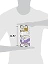
| Dimensions | 4 x 0.1 x 8.5 inches |
| ISBN-10 | 1931257116 |
| ISBN-13 | 978-1931257114 |
| Item Weight | 2.24 ounces |
| Language | English |
| Print length | 1 pages |
| Publication date | January 1, 2015 |
| Publisher | Streetwise Maps |
A**H
Excellent *Map* With Subway Station Numbers!
The STREETWISE TOKYO MAP was really helpful for my first trip to Tokyo this month. Not only does it break Tokyo down into the separate districts like Shibuya, Shinjuku, Asakusa, etc., it provides icons for big hotels and landmarks, so that you can figure out where you are, and there's also a Tokyo area map showing all of the districts within Tokyo. Another really good thing about the map is the listing of subway/train station numbers and lines. This was really helpful in figuring out the route from point A to point B. We learned the hard way that Tokyo isn't an area that you can walk from one place to another, unless you're really familiar with the streets, because they aren't logically set up like here in the states. The streets of Tokyo branch out and twist and turn and you can get lost very easily! We got lost about 3 or 4 times, even when we were walking in what seemed like a straight line. Luckily, the STREEWISE TOKYO MAP shows the subway and train lines so you can just follow along the appropriate line to get from where you are to where you want to go and then head down to the station. Because the subway lines have a combination of letters and numbers, i.e. the Marunouchi line is listed on the map and in real life as "M" plus a number denoting the station stops, it's really easy to figure out which line you need to be taking and at what number stop you need to get off at. Trust the map and the numbers because there was one anomaly that appears in the Shibuya area of the map and Shinjuku. Actually it isn't an anomaly but if you walked the area, we walked from the Tokyo Gymnasium back into Shinjuku where we were staying, it would seem that Shibuya is actually above Shinjuku, but it's not. So when we decided to ride the Fukutoshin Line to get to Harujuku, after getting hopelessly lost on foot, we noticed that the station stop numbers were getting higher, instead of lower, but it was right on. The above probably makes no sense, but if you've ever walked the streets of Shinjuku and Shibuya you'll know exactly what I'm talking about. Anyway, the map is great for finding your way when you become lost, or may actually prevent it, and it'll help you figure out the subway and train lines so you can get to where you need to go.
M**S
A great tool for touring Tokyo
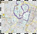
I carried this highly useful map all over Tokyo in my back pocket during a recent visit and was able to travel easily throughout the city. It's much more useful than the maps included in the guide books I have read. The combination of color, letter, and number that codes each subway station makes it very easy to know where to go and when to get off. On the larger maps, each station shows exit numbers that match the large black-on-yellow signs underground and help you to get out in the right direction. Note that it's most useful to combine this map with a debit-card-like subway/train pass (either Suica or PASMO), which you can even buy in the basement of the Narita airport. When you leave Tokyo for good, take your pass to the office at the nearest subway station and they'll refund most of your remaining money. (BTW, if you have access to a WiFi connection, try entering origin and destination in Google Maps and clicking on the subway icon.) Pros: A reasonably small size makes this map portable, but it's still very legible. The close-up maps show subway station exit numbers, block numbers, and even outlines of high-rise buildings in the vicinity. The map is laminated and is still in excellent shape even after our return. Cons: Not every neighborhood of Tokyo is shown in close-up view. To name just a few areas, Sengakuji station, the Yanaka neighborhood, and Ryogoku station (Edo museum) are only shown in less detail (but the map is still useable).
E**H
Great map
There are great tourist maps in Tokyo that you can get at the information/tourist centers, but if you are going to be in the city for any period of time, this is essential. The other tourist maps will rip and tear easily and this is good-quality. Would like for it to also include a subway route image as well. Overall...good purchase for me, but not necessary if you are only in Tokyo for a very short stay.
D**R
Good map series.
I buy from this Street Wise series even if I am only going to spend 2 or 3 days in a city. Shows the train stations, some buildings by name, and the Tokyo map even shows if there is a street light at an intersection. I generally prefer StreetWise over a paper map because I just have to fold it left to right, not top to bottom as well. And the maps are hardy. Someone more familiar with the city might be able to you why the train station "Aoyama 1 chome" in the 2010 edition of the map is sometimes written as Aoyama i chome in other sources. Free advice: take a small skinny sharpie to mark / circle where you want to go. Tokyo is such a big city that you might wish you didn't keep having to locate, for example, your hotel or Tokyo Tower every time you open it. Since it's well laminated, a sharpie marker will probably work best.
P**5
exemplary design: max info + max clarity
i used this everyday during my stay in Tokyo. it was easy to use and reliable. it proved the best of several guides i had purchased and the only one i actually needed during the month long visit. it is amazing how much information is clearly presented in this small map/guide. it is expertly designed, beautiful and functional. it is also sturdy, which is good because if you want only one street map then this is it and you will keep referring to it as it is also a guide. it provides a wide range of necessary information, correlates metro lines/stations with neighborhoods and sites, and even includes sub-district names and numbers and block numbers. the intelligent use of upper and lower case, regular, bold, italic, and outlines, and color provides great clarity. it could keep you busy for a lot of your flight and you would be well informed when you land in Tokyo.
C**P
This was a great map, which was easy to slip into a bag, could deal with rain, and was very useful for a week's sightseeing round the city. Guidebooks offer small one-page maps of individual districts; without the 'big picture' that this map showed, we'd have been a lot more confused than we were! BTW, don't expect street names in Tokyo; the naming and numbering system doesn't work that way.
A**E
Plan excellent et indispensable! Seule dans cette ville géniale en mars 2015 j'ai beaucoup compté sur ce plan plastifié et je m'en suis sortie très bien pour m'orienter dans les bonnes directions! Je recommande les yeux fermés ;)
C**H
The color is so bland and maps so tiny - not every useful when walked around. Also the map is flipped from one side to another, painful to view and read.
F**N
Nos ayudó mucho. Buen precio y buena calidad. Lo mejor: al ser plastificado dura más tiempo e incluso lloviendo se puede usar.
M**H
Out off all the city guides and maps we purchased before going to Tokyo this is the only one we used daily during our time there Small, laminated, easy to read - fantastic! Ensured we kept this safe for our next trip there
Trustpilot
2 days ago
2 months ago